Minnesota Department of Transportation

511 Travel Info

Highway 3/South Robert Street

West St. Paul

Study complete

About this study
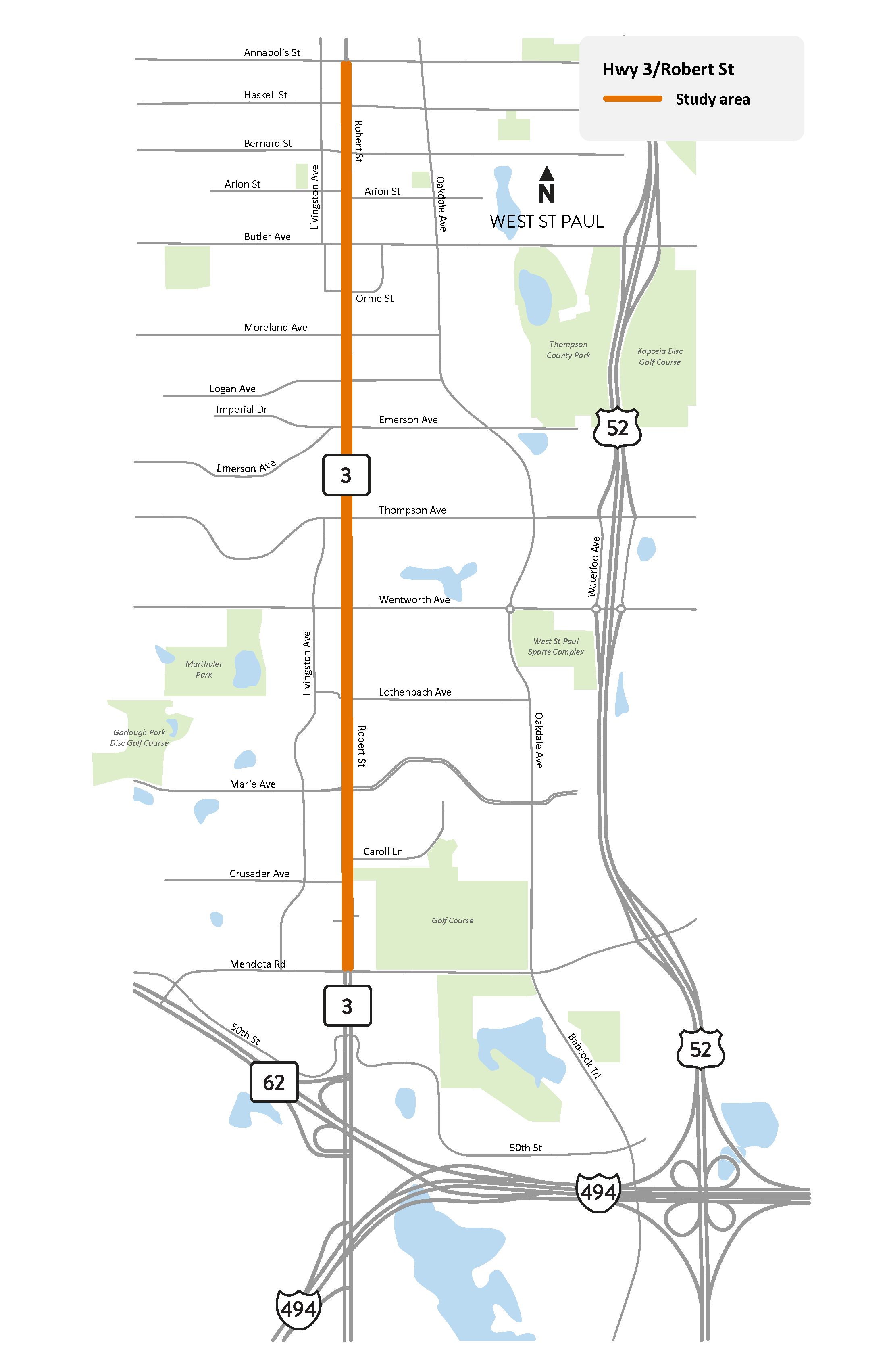
Highway 3/Robert Street from Mendota Road to Annapolis Street in West Saint Paul study location map

South Robert St. in West St. Paul study area map

View full-size map

In 2024 and 2025, we studied Hwy 3/South Robert St. between Mendota Rd. and Annapolis St. in West St. Paul to identify possible improvements to safety and connectivity for people who walk, bike, ride transit and drive.

This section of South Robert St. was reconstructed in 2015-2016 to improve transportation mobility, access management and safety. The reconstruction added a center median to restrict hazardous left turns, consolidated driveways along the road to simplify access and installed new traffic signals, streetlights and landscaping. Despite those improvements, the section of roadway has seen continued safety concerns for users since completion of the reconstruction project.

This study was coordinated with Metro Transit to prepare the area for the G Line arterial Bus Rapid Transit service, which will include new on-street transit stations in the study area.

Summary of work

  • Assessed and reported on existing conditions
  • Asked people to share their transportation experiences and needs
  • Developed and recommended ideas for improvement
  • Coordinated with the planning, design and construction of Metro Transit’s G Line arterial Bus Rapid Transit service

Study findings

During the study we conducted two rounds of engagement to gather community input on South Robert St. The study team collected input from the public with community pop-up events, public meetings and online surveys. During May and June 2024, we focused on identifying key concerns for traveling along and across South Robert St.

Themes from the first round of public engagement included:

  • Speeding
  • Expanding and improving connectivity and safety for people walking and biking
  • Dangerous left turns
  • Need for improved transit amenities
  • Sightline concerns

During the second round of engagement in October and November 2024, we focused on getting input from the public on proposed concepts for improving safety and connectivity. For more details on the second phase of engagement including the feedback on the proposed concepts, read the Safety Concept Recommendations report (PDF)

Based on existing conditions and the evaluation of issues, goals, objectives, and public input, the following study area need topics were identified:

Safety
  • Reduce speeding
  • Reduce the number of crashes
  • Improve safety of people walking and biking along and across South Robert St.
Walkability and bikeability
  • Increase connectivity for people walking or biking along and across South Robert St.
  • Increase accessibility for people walking or biking accessing properties and transit stations in proximity to South Robert St.

Information gathered during engagement, and the existing conditions and study area needs were used to help with the development and analysis of ideas for improvements. These are some of the concepts recommended from the study:

Signal timing/phasing changes
  • Protect left-turn phasing: Switching to protected left turns (left only on green arrows) from flashing yellow arrows during peak travel hours on South Robert St. would reduce conflicts between cyclists and pedestrians. Some intersections already use this treatment.
  • Leading pedestrian intervals: Leading pedestrian intervals enhance pedestrian safety at intersections by showing the walk signal 3-7 seconds before vehicles receive a green light, increasing pedestrians' visibility to drivers. MnDOT installed leading pedestrian intervals on South Robert St. in fall 2024 during the study.
  • Limit right turns on red: Right-turn-on-red lights creates a conflict point between people walking and driving. Restrictions are recommended at intersections with poor visibility and/or high pedestrian crash rates.
  • Update signal timing to reduce speeding: Retiming green light phases on South Robert St. will allow for vehicles to travel continuously at posted speed limit. Drivers who speed would experience more stops at red lights.
  • Implement pedestrian recall: Pedestrian recall ensures pedestrian signals activate every signal cycle without being pushed, which is ideal for intersections with high pedestrian and bicycle traffic.
Pavement marking and signage
  • Pedestrian crossing enhancements: Implement high-visibility continental crosswalks at all crossings along and across South Robert St., pairing advanced stop bars with crosswalks and pedestrian-activated warning devices at certain unsignalized crossings are recommended to improve pedestrian safety on South Robert St.
  • Narrowing lanes (through pavement striping): Adding lane markings to the outside lanes of South Robert St. can visually narrow lanes and encourage slower driving speeds.
  • Tighten curb radii with pavement markings and bollards: Tightening corner radii reduces vehicle turning speeds, improves pedestrian visibility, shortens pedestrian crossing distances and creates better aligned curb ramps. These changes can be tested with pavement markings and bollards before permanent implementation.
  • Dynamic speed feedback signs: Displaying driver speeds and "slow down" messages can deter speeding especially when combined with other traffic calming treatments or in areas with changing speed limits.
  • Install "No U-turn" signs at locations with a history of U-turn crashes: U-turn restrictions at crash-prone intersections must be balanced with maintaining adequate access along the continuous median area.
Curbline and geometry changes

The concepts below require permanent alterations to the curblines, geometry and pavement along South Robert St. and intersections with cross-streets and are intended to be installed in coordination with the Metro G Line construction in 2028.

  • Permanently reduce curb radii: Tightening corner radii reduces vehicle turning speeds and improves pedestrian visibility and curb ramp alignment. Corner radii tightening may not be feasible at locations where large trucks frequently turn.
  • Positive offset left turn lanes: At most signalized intersections along South Robert St., left turning vehicles in the opposing left turn lane block sightlines to oncoming traffic, which reduces ability of left turners to sufficiently judge gaps. This is true to the left turn lanes having a negative offset design. Positive offset left turn lanes can improve sightlines by shifting both lanes to the road's center.
  • Install additional mid-block crossings: Mid-block crossing opportunities will be considered at midpoints between intersections where crossing demand is high and near planned G Line stations.
  • Hardened centerlines or extended median noses: Hardened centerlines can use mountable curbs to discourage drivers from cutting across the centerline as they turn and encourages them to make left turns at slower speeds. This improves safety for pedestrians crossing at the intersection, as slower vehicle speeds reduce crash risk and crash severity.
  • Extended curbs at 3/4 intersections: Right-in/right-out/left-in-only (3/4) intersections, like those at Orme St. and Logan Ave. on South Robert St., could benefit from having the curb extended from the centerline median to physically prevent motorists from making unexpected and illegal movements.
Longer-term projects

We have identified additional improvement concepts for the study area, but they require more time to analyze and more resources and coordination with businesses along the study area, the West. St. Paul Police Department, the city of West St. Paul and Dakota County. These concepts also require permanent alterations to the curblines, geometry, pavement, landscaping, and access driveways along South Robert St. and the intersections with cross-streets.

Please view the Safety Concept Recommendations report (PDF) for more information regarding improvement concepts.

Next steps

The concept recommendations from this study will be used to further design the construction project on South Robert St. in 2028. We are coordinating the construction to occur at the same time as the Metro Transit G Line construction to minimize disruptions to the community.