Bicycling in Minnesota | Routes and Maps | U.S. Bicycle Route 41 | About the route
About U.S. Bicycle Route 41
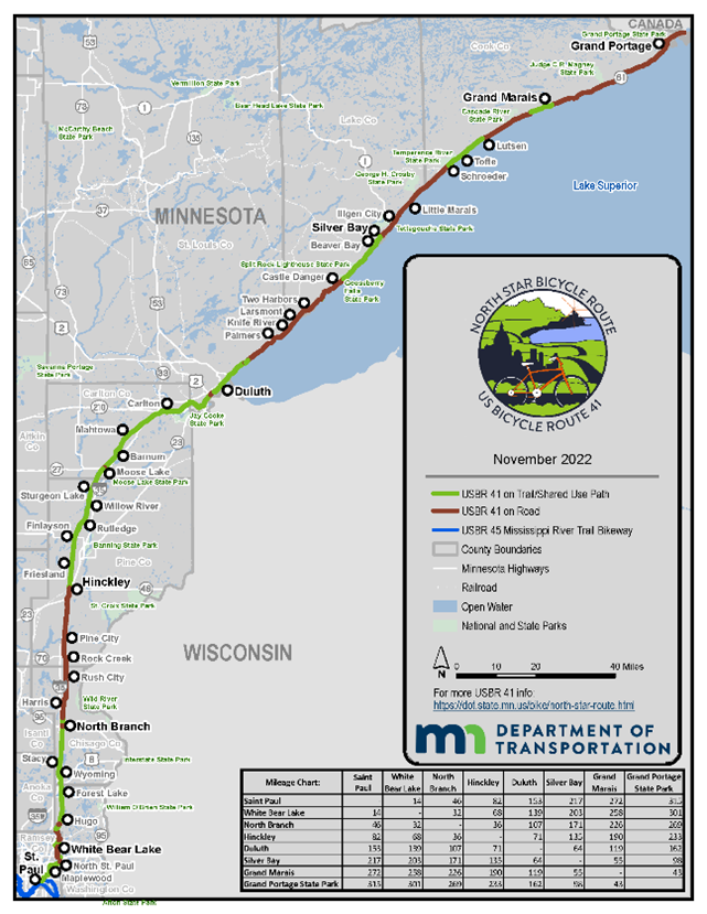
U.S. Bicycle Route 41, designated the North Star Bicycle Route, connects Minnesota’s State Capitol and USBR 45 / Mississippi River Trail to Canada.
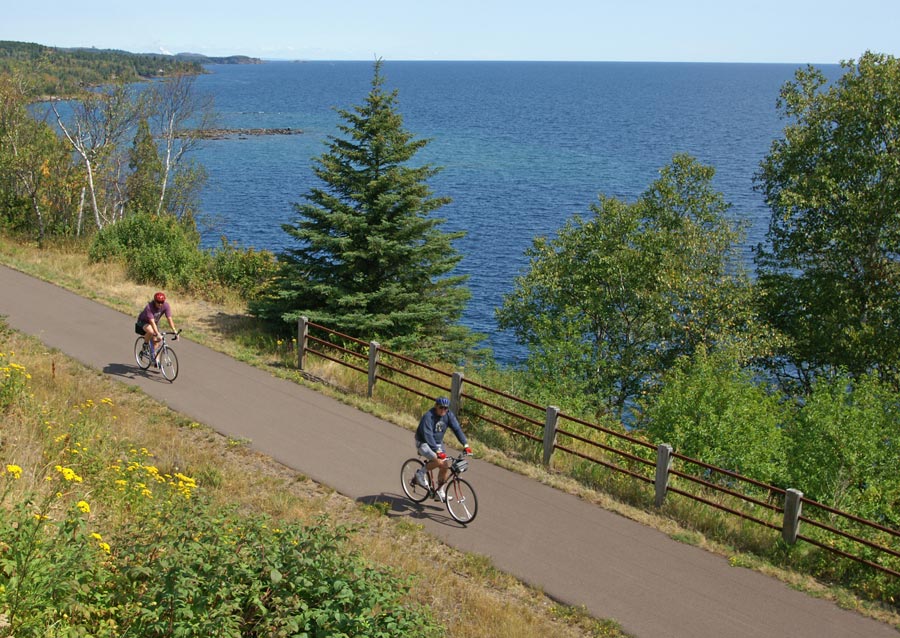
Gitchi-Gami State Trail
Location and length
USBR 41 travels northward 315 miles from its start in Saint Paul at the junction of USBR 45 / Mississippi River Trail, to the end at Grand Portage State Park at the Minnesota/Canadian border. Nearly half the route follows state, regional, and local trails, with the remaining segments located on the shoulders of paved roads or on shared lanes.
Bicyclist and route profile
With nearly half of USBR 41 on regional and state bicycle trails, there are segments suitable for all types of bicyclists. Bicyclists riding the entire route must be experienced and capable of sharing the road with cars and trucks.
USBR 41 was developed for adult bicyclists with a driver’s license and several years of bicycling experience. Most roads have no special provisions for bicyclists; you must assume responsibility for your own safety and practice defensive cycling. For young or less-experienced bicyclists, there are many miles of trail available for your skill level.
Between St. Paul and Duluth
USBR 41 between St. Paul and Duluth is largely on state and regional trails;when on roads, shoulders are generally 4 feet wide or greater. Shoulders may narrow at guardrails, bridges, rumble strips and right turn lanes. Posted road speeds range from 30 mph within cities to 55 mph between cities.
Between Duluth and the Canadian border
USBR 41 north of Duluth closely follows the North Shore of Lake Superior. The route is on nearly 10 miles of Duluth’s city trails and approximately 30 miles of the Gitchi-Gami State Trail, with the remaining miles on road shoulders along Scenic 61 (Duluth to Two Harbors) and Minnesota Hwy 61 (Two Harbors to Canadian border). Road sections are mainly two-lane and part of the North Shore Scenic Drive. The posted road speeds are typically 55 mph, or 30-40 mph within cities/tourist areas.
There are intermittent sections between Two Harbors and Cascade River State Park (panel map numbers 8-11) where the shoulder is narrower than 2 feet with a 55 mph posted speed. Shoulders may also narrow at guardrails, bridges, passing zones, rumble strips and right turn lanes. This section of the route is continually being improved through the ongoing development of the Gitchi-Gami State Trail.
Average daily traffic volumes on Hwy 61 north of Two Harbors range from approximately 1,500 to 6,800 vehicles, with volumes decreasing towards the north. See the MnDOT Traffic Mapping Application for traffic volumes.
Safety
On-road segments
Over time, agencies and advocates plan to build more miles of trail separated from motorized traffic. Until more trail is built, bicyclists on all road shoulders must be experienced, capable of sharing the road with cars and trucks, and bicycle defensively due to the traffic speeds, volumes, and lack of separation from motorized traffic.
If you are not an experienced bicyclist, there are many miles of trail available that are better-suited for your skill level. USBR 41 panel maps indicate locations where shoulders are narrower than 4 feet and where trail exists.
Rules of the road:
When traveling on roads, bicycles are nonmotorized vehicles. Bicyclists are encouraged to "drive" appropriately:
- Ride safely and abide by the rules of the road.
- Ride single file with traffic.
- Follow best practices and position yourself appropriately based on the road speed, volume and shoulder/lane conditions.
- Use hand signals to indicate turns and movements.
- Stop at stop signs and signals.
- Be considerate about when and where your bike is parked and locked.
Off-road segments
Parts of the route on paved trails suit bicyclists of all abilities and experience levels. Interactions with car and truck traffic occur at intersections and trail crossings. Share paved trail spaces with other bicyclists, pedestrians, and families with small children. Make sure to alert them of your presence.
Grades and accessibility
Compared to bicycling in the Appalachian or Rocky Mountains, this route is relatively flat. This is especially true for those traveling the Bruce Vento, Gateway, Hardwood Creek, Prairie Sunrise and Willard Munger Trail segments.
Roughly half of USBR 41 is on regional and state bicycle trails that, wherever feasible, meet Americans with Disabilities Act grades. Some of the trails were constructed on abandoned railroad grades and are relatively flat and constructed with accessibility considerations important to a variety of the users. The Gitchi Gami State Trail between Gooseberry Falls and Beaver Bay (panel map number 9) includes some sections with steep hills and curves. The area near Mount Josephine (near Grand Portage; panel map number 13) also includes hilly terrain. The USBR 41 panel maps include elevation profiles.
Destinations, accommodations, and points of interest
- Saint Paul to Duluth: Mississippi National River & Recreation Area, Union Depot, White Bear Lake, Bald Eagle – Otter Lakes Regional Park, Hinkley Fire Museum, Jay Cooke State Park
- Duluth to Grand Marais: Duluth North Pier Lighthouse, Brighton Beach, Two Harbors Lighthouse, Gooseberry Falls State Park, Split Rock Lighthouse, Black Beach, Tettegouche State Park, Temperance River State Park, Cascade River State Park
- Grand Marais to Grand Portage: Grand Marais Lighthouse, Judge C.R. Magney State Park, Grand Portage National Monument, Grand Portage State Park
Numerous private and public camping sites are available, including at the nine Minnesota State Parks along the route. Hotels can also be found in many of the towns located on the route.
More Information
- Gateway State Trail
- Hardwood Creek Regional Trail
- Sunrise Prairie Regional Trail
- Willard Munger State Trail
- Cross City Trail
- Superior Hiking Trail
- Gitchi-Gami State Trail
- North Shore Scenic Drive
- Explore Minnesota
- North Shore Visitor
- Mississippi National River and Recreation Area
- Superior National Forest
- Grand Portage National Monument
- Visit Saint Paul
- Lake County Chamber of Commerce
- Visit Duluth
- Visit Cook County
- Grand Portage Band of Lake Superior Chippewa